
Originally published as a paid partnership on Explore Magazine
Has the last year resulted in you feeling directionless? As we struggle with feeling somewhat lost these days, one good strategy can be to get out and try something new. We’ve seen that with the huge influx of new participants into outdoor activities over the last year. Orienteering is one of those activities that has seen growth as folks look to try new activities and be outside in a safe way. Orienteering is a great way to get some outdoor physical activity into your routine while building navigational skills that are transferable to other outdoor adventures.
 Orienteering Canada
So, what is orienteering?
Orienteering as a sport is a cross-country running race, but instead of knowing the exact route that you’ll take in advance, you can choose your route all throughout. Your goal is to get from the start to the finish as quickly as possible, and along the way there are checkpoints that you need to navigate to using map and compass. There are electronic devices at each checkpoint to validate that you were there.
Why is orienteering awesome?
The sport requires a keen balance between your physical and mental capabilities. You need to stay focused on your route choices, while keeping track of where you are and where you are going, while trying to move as quickly as you can. Many converts to orienteering love the challenge of combining the mental and physical elements of the sport.
 Rock Gear
Are there different types of orienteering?
The most popular orienteering is done on foot—either running or walking. The International Orienteering Federation officially has four disciplines: orienteering on foot, cross-country ski orienteering, mountain bike orienteering and trail orienteering, a discipline which can be done by individuals with mobility impairments.
Within the competitive world of orienteering by foot, there are three distances of races. The “sprint” race takes somewhere between 15 and 30 minutes. Sprint races are often in urban parks and across university campuses in North America. A favourite venue for sprint orienteering is through medieval town centres in Europe. The “middle” and “long” distance races take 30 to 45 minutes and 60 to 120 minutes respectively, and these races are usually held in forested areas with lots of interesting, varied terrain.
A cousin to orienteering is the sport of rogaine. Rogaine events last from three to 24 hours and use a less detailed map similar to a topo map. Some folks are drawn to the longer format of rogaines, while others prefer the length of orienteering events.
How does an orienteering event work?
To take away the intimidation factor of trying your first orienteering event, we’ll break it down for you and give some tips.
The key part to successful orienteering is being able to read your map. At the start line, you are handed a map with marked checkpoints. There will be a triangle on the map to indicate where you are at the start of the race. From the triangle, you scan to see where the first circle is on your map. That’s your first checkpoint (we call them controls in orienteering lingo). Now you need to decide how you are going to get there. Maybe there is a hill between you and checkpoint #1, do you want to go up and over the hill or around it? Maybe there is a trail you could take, but it’s out of the way—do you go straight and stay off-trail or do you decide to take the time to get to the trail knowing that you’ll be able to move faster on the trail, versus going directly through the bush? It’s those route choices throughout your race that make the sport so unique and fun. At each checkpoint you will find an orange and white “flag” along with a control number marked on both the checkpoint and your map, as a double-check that you are at the right spot. Also printed on your race map is a list of the checkpoints that you need to find with a little pictorial description of where you’ll find the flag, such as on the north side of a knoll, or the upper part of a valley. This description exactly matches the terrain that is indicated in the middle of the checkpoint circle marked on the map.
 Orienteering Canada
Orienteering is a true sport for life meaning that there may be six-year-olds to 90-year-olds at an orienteering event, as well as beginners to experts. The event organizer (the person who decides where the checkpoints will be) takes that into account and makes the route choice options simpler for some and quite challenging for the more experienced. So if you are at your first orienteering event, there will be an appropriate level for you.
It’s common at the end of a race to compare the routes that you chose with the routes that your competitor chose. People often ask “well, can’t I just follow my competitor?” A race is set up with staggered individual starts, so you do need to make your own route choices along the way.
Our top tips for someone just starting:
- Keep your map oriented to the terrain
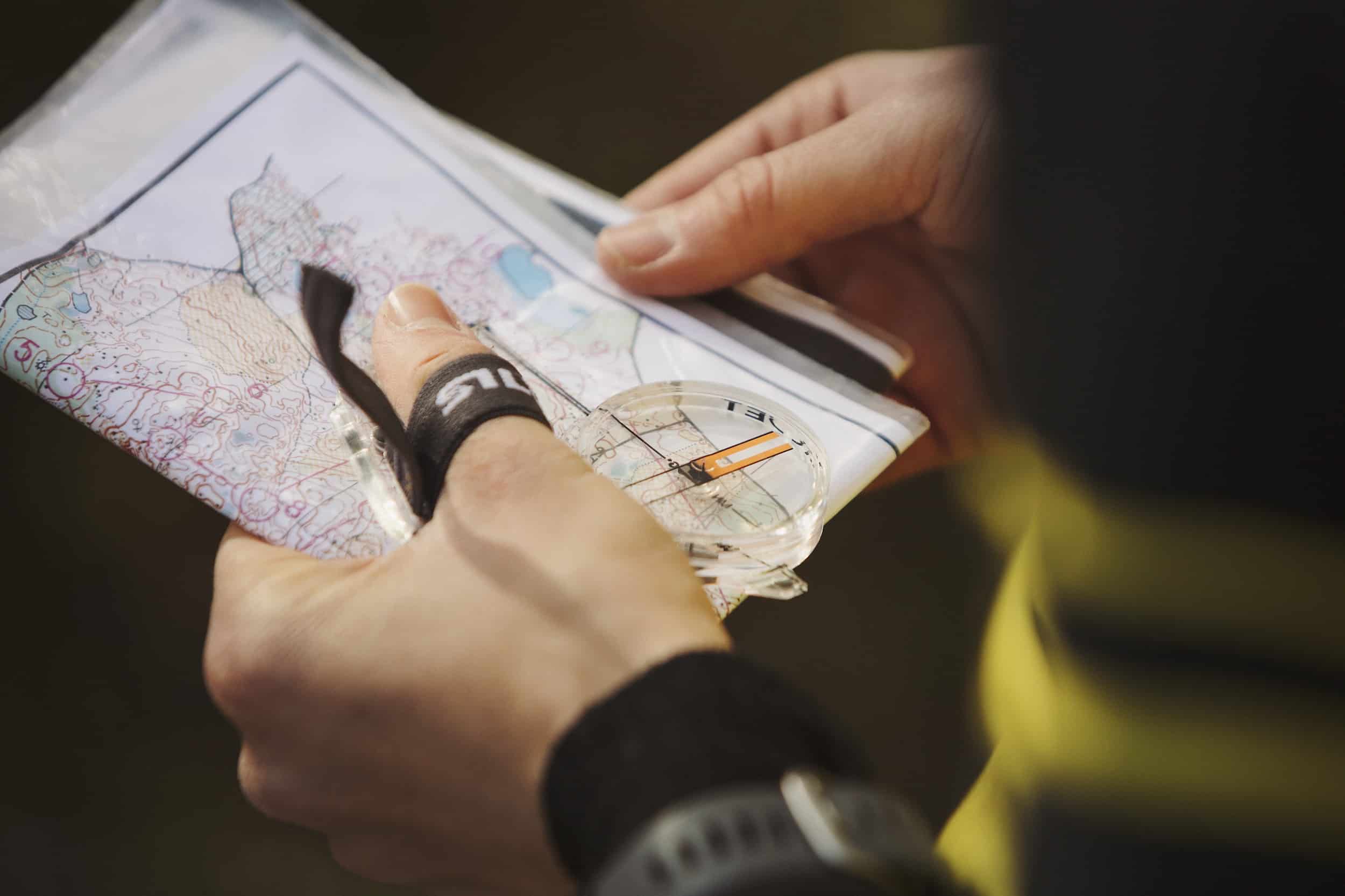
Use the land features around you to orient your map (for instance, if you are by a trail, make sure that you hold your map so that the direction of the trail on your map matches the direction of the trail in the terrain. You can also use a compass to do this, by matching up north on the compass with the north lines on the map). - Fold your map and use your thumb to keep track of where you are
At each checkpoint, refold your map so that you can easily hold it in your hand and see your route from where you are to the next checkpoint. As you move through the terrain, move your thumb along so that your thumb is pointing on the map to match where you are in the terrain.
 Silva Canada
What’s special about an orienteering map and how the heck do I figure out how to read it?
The orienteering map is a piece of beauty. It’s a very detailed map that is usually a 1:5,000, 1:10,000 or 1:15,000 map scale. There are international standards for making orienteering maps so although the actual terrain will vary, the way to interpret the map is the same all over the world. The colours on the map give lots of information:
- Anything brown refers to land features. The brown lines tell us about the shape of the terrain: the big hills, small hills, valleys, gullies and knolls. The closer the brown lines are to each other, the steeper the incline. It is normal in orienteering to have a contour interval of five metres, meaning that each brown contour line indicates a five-metre change in elevation. There are tiny little brown tick lines that tell you what direction the incline is to help you figure out which way is up, and which way is down.
- Anything blue on the map refers to water features: lakes, streams, rivers, marshes, small ponds, etc.
- Anything black in the map either refers to rock features such as boulders and cliffs, or man-made features such as trails, buildings, fences, power lines, etc.
- The green and yellow on the map refers to the vegetation density and the different shades of colour range from wide open clearings to dense forest.
The map legend also gives you lots of great info.
How do I get started?
There are about 25 clubs across Canada. The best way to try the sport is to contact an orienteering club in your area. During Covid, many Canadian clubs have adapted by having people download their own map and use an orienteering specific app that will beep when the participant is at the checkpoint. This way people can orienteer on their own time and the clubs don’t have to have physical checkpoints in the terrain. Contact your local orienteering club and tell them that you are new to the sport and they'll help you get started. Things are a little trickier because we are not having our traditional events, yet orienteering clubs have been very resourceful in finding safe ways for people to get out orienteering.
Another beautiful thing about the sport is that it is truly a sport for life. There are age categories from 10 to 95 at the national championships. You can choose your speed of travel. You are welcome to walk if you don’t want to run; in fact many people are out there for the challenge of the navigation, and not concerned about speed.
What equipment is required?
Orienteering has a low barrier to entry. It’s not very expensive to join a club or take part in an event and the equipment needs are low. Clothing-wise you need to wear something that can withstand running through the trees and may get dirty along the way. A good sturdy trail running shoe works well.
If you get more into orienteering, you’ll likely want an orienteering specific shoe such as Icebug’s Spirit8 OLX shoe which is a lightweight trail runner with studs to help with traction over rocks and logs in forest orienteering (and makes a great winter running shoe too). When you start the sport, you don’t necessarily need a compass, but as you get more experienced you will want a compass to help you orient your map properly and to help you move through the terrain in the right direction. There are two sorts of compasses used in orienteering, the baseplate compass that you place directly on your map or a thumb compass that attaches to your thumb so you can hold your compass and your map in the same hand. This spring, Silva Canada is launching their new series of orienteering thumb compasses: the Silva ARC Jet Series.
 Rock Gear
How do orienteering skills help with other activities?
Getting skilled at orienteering helps with your other outdoor adventures too. Although the map style may not be the same, a skilled orienteer understands how to interpret contours and can visualize the landscape ahead. An orienteer understands the importance of orienting the map to the terrain and how to use your compass to take bearings to make sure you are going in the direction that you want to go. Orienteers are level-headed about being lost (we generally don’t call it being lost, we call it being momentarily disoriented) and learn tips and tricks to figure out how to get back on track.
We hope you give orienteering a try this spring! Watch Orienteering Canada, Silva Canada, Icebug Canada and o-store.ca’s Instagram and Facebook.
Super helpful resources:
- A great intro sheet from Orienteering Canada to take along with you to your first event:
orienteering.ca - I love these orienteering reference guides from a Canadian orienteering equipment online store. You can download the pdfs for free or purchase a set either on waterproof paper or laminated: o-store.ca
Paid partnership with SILVA Canada and Icebug Canada