

For some, the idea of a vacation conjures visions of lying out on a beach under a blazing sun. For others, it just isn’t a break from the grind unless you're miles away from any other human being. We can say with certainty though, it's not a holiday nor an adventure these days unless you're totally unplugged. We invite you to stow away the laptop, the smartphone and the tablet; those items that demand connectivity. For the adventure traveller, Canada is one of the wildest destinations in the world. Between three oceans, cragged mountains, remote rivers, lonely glaciers and even volcanoes, it's no challenge to get completely off the grid. Here are eight awe-inspiring corners of Canada that are guaranteed to push your boundaries.
Before you go adventuring off the grid...
Warning: this post is likely to incite unbridled wanderlust. Canadian Traveller will be held responsible for chronic daydreaming, however, we will not be liable for those venturing into the wilderness ill-prepared.
All of these adventures have one thing in common: views to die for. This term though, is too casually coined; often times to over-hype a destination. We take the idiom of 'views to die for' pretty seriously. Off the grid adventurers should plan for the worst and hope for the best vacation weather. Beyond garnering outdoor smarts or leaning on the expertise of local outfitters, toting the proper gear is essential. At the top of our list? Reliable communication. These adventures are boundary pushing because they take you beyond cellular networks. However, without having a plan to ensure reliable communications, getting away from it all could mean running the risk of not being able to call for help when you might need it most. The simple solution is clipping a lightweight SPOT Gen3 satellite messenger to your pack. The device provides real-time S.O.S. communication and is connected to the world's most modern satellite network. It can track your route and pinpoint your location with GPS accuracy, taking the search out of ‘search-and-rescue’. Having been used to initiate more than 3,500 rescues worldwide (over 1,000 in Canada) SPOT Gen3 is essential gear for today’s outdoor adventure seeker.
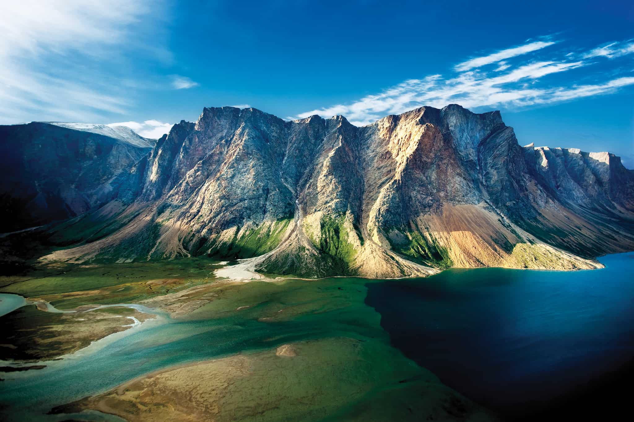
Ivvavik National Park, Yukon

Duration: 5 days + travel time to Inuvik
How is it boundary pushing? Ultra remote setting means visitors may not run into any other parties.
Trip notes: Average summer temperatures in the park range from +8 °C to +20 °C. Hikers should be very aware they are venturing into bear territory - black, grizzly and polar.
Park website: Click here
About: This incredible national park was the first to be established as the result of a land claim agreement with First Nations. It’s also a protected area for the Porcupine caribou to calve in safety. And where there are caribou, there are wolves and bears. Ivvavik borders the Arctic National Wildlife Refuge in Alaska and the Vuntut National Park to the southeast.
The vast wilderness to the north has amazing adventures for the skilled backpacker. A five-day adventure starts in Inuvik with a bush plane ride to base camp, where Inuvialuit hosts are waiting to share their culture. From base camp the hiking choices vary in difficulty and length – although none are a walk in the park. (Pun intended!) The ability to navigate is critical as there are no maintained trails in Ivvavik.
Independent rafting enthusiasts will be pleased to hear that they can navigate the Firth River. Canada's oldest flowing river, it is classified as a Class IV wilderness river. With strong currents, eddies, cold temperatures and risk of flash floods, those who endeavour on the excursion should be prepared to self-rescue if needed. Alternatively, several outfitters with longstanding Firth River experience run multi-day or week-long expeditions.
Gwaii Haanas, British Columbia

Duration: No set commitment; depends on your interests. Venture in for a single day zodiac tour or secure a week-long kayak rental.
How is it boundary pushing? Perched at land's end, the 138 remote islands that make up this UNESCO world heritage site are subjected to wild open seas and have no roads.
Trip notes: Access to the park is by boat or plane only, and independent visitors arriving May through September will require a reservation.
Park website: Click here
About: The “Islands of Beauty” lie off the coast of British Columbia and are managed by both the Canadian Government and the Council of the Haida Nation. In addition to the Haida Heritage Site, which encompasses both land and sea, the National Marine Conservation Area Reserve protects the ecosystems, balancing economic usage with maintaining a diverse marine environment.
The shallow shelf that the islands sit upon drops off dramatically on the western side, creating an amazingly diverse region between the continental shelf and ocean's abyss. A kayak adventure into Gwaii Haanas includes an up-close view of tidal pool inhabitants when the tide is out, and the occasional whale or dolphin sighting off the coast. Don’t leave the national park before visiting Haida culture sites to learn a bit about the people who have called the islands home for more than 12,000 years.

Mount Edziza, British Columbia

Duration: 7-10 days + travel time to trailhead
How is it boundary pushing? Remote volcano enveloped by unspoiled wilderness. Translation: no maintained hiking trails lead to Eve's Cone or the other volcanic cinder cones on the Edziza Plateau.
Trip notes: The best time of year to backpack in the park is between July 1 and September 15. A warning from the BC Parks website reads, "Visitors may access the trail from Kinaskan Lake Park to Mowdade Lake via an un-official route from the end of Willow Creek Forest Service Road. This is an unmaintained roadway and there are several areas that are susceptible to overgrowth, flooding and/or washouts. Access is feasible but challenging and a 4x4 vehicle along with strong knowledge of the Willow Creek area is necessary. The official access trails in to Mt Edziza Park are unmaintained, overgrown in sections and do not have bridges over creek crossings. Visitors are asked to use caution when crossing waterways."
Park website: Click here
About: In northwestern British Columbia, one of Canada’s highest volcanoes is surrounded by stunning parkland, topped with multiple glaciers. Three main peaks surround the ice-filled caldera, and much of the landscape in the provincial park was shaped by the volcano. Access is difficult, adding another layer of protection to the pristine wilderness that attracts the eye of wander-lusting hikers from around the globe.
Access trails to the park are unmaintained, overgrown and may require water crossings. Once in the park, the conditions are challenging and hikers require protection from freezing temperatures (even during the short summer). Satellite communication is imperative and if relying on a compass for direction, take into account the iron in the mountain that can alter the direction of the needle. No supplies of any kind are inside the park boundaries.
Wabakimi Provincial Park, Ontario

Duration: Multi-day; depends on your interests and where you enter the park.
How is it boundary pushing? 2,000 kilometres of remote lakes and waterways offer untouched wilderness for the intrepid backcountry paddler.
Trip notes: 500 primitive campsites throughout the park. Most popular time for canoe excursions is mid-May through mid-September. Not all canoe routes are maintained, nor are all portage routes.
Park website: Click here
About: Getting to this remote, watery wilderness in the northern part of Ontario requires a bit of planning – and something that floats. The network of lakes and rivers can be accessed via Armstrong Station and Little Caribou Lake, or by rail that skirts the southern end of the provincial park.
Once in the park almost 2,000 km of waterways await the adventuring canoeist. The boreal forest surrounding the rivers and lakes is prime habitat for a variety of wildlife, and the water is home to numerous fish including wall-eye and northern Pike. The opportunities for wilderness adventure are endless. There are even fly-in lodges and resorts for those who want to visit areas of the park that are too far to paddle to.

Torngat Mountains
Newfoundland and Labrador

Duration: Multi-day
How is it boundary pushing? The park requires everyone entering the area to register and demonstrate adequate polar bear deterrents. Enough said.
Trip notes: A base camp is staffed from mid-July through the end of August. It largely caters to researchers but packages are available for paying guests. Facilities include accommodation, washrooms, a kitchen, laundry, satellite phones, medical personnel, hot showers and meals, in addition to helicopter and zodiac boat transportation.
Park website: Click here
About: The peninsula separating Ungava Bay from the Atlantic has 9,700 sq. km of national park that protects polar bears, caribou, golden eagles and peregrine falcons, among other wildlife. It is referred to as the “Place of Spirits” and has been home to the Inuit for thousands of years. To this day they continue to use the area for hunting and fishing, respecting the gifts the land offers.
The northern marine location has geological features found in very few places. Icebergs float in the Labrador Sea while glaciers dot the mountain peaks. Polar bears hunt along the coast and herds of caribou cross cold rivers migrating from calving grounds to grasslands. To experience the diversity of northern Canada, the Torngat Mountains are the ideal place to visit.
Wood Buffalo National Park, Alberta

Duration: Multi-day
How is it boundary pushing? Backcountry hiking and canoeing takes you through remote boreal plains and uplands, with some routes requiring the assistance of licensed park guides. Entering a bison habitat also means proximity to predatory wolves.
Trip notes: Shorter, one day 'frontcountry' hikes found in the Salt River Trail System, Sweetgrass Station is a favoured backcountry route, and there are more than 8 major navigable waterways.
Park website: Click here
About: Counted among the largest parks in the world, Wood Buffalo National Park was established almost 100 years ago to protect free roaming wood bison. The park is also home to one of Earth's largest fresh-water deltas. The landscape is characterized by Karst sinkholes, has resident whooping cranes and is the world’s largest dark sky preserve. (An area kept free of artificial light pollution.)
Wood Buffalo is five times the size of Yellowstone and a person could spend months here without feeling as though they’d seen everything. Hiking trails take visitors to amazing viewpoints, and cabins in the backcountry provide a secluded overnight spot for watching the northern lights and owl spotting. Hiking trails pass a number of Aboriginal cultural sites and reserves.
Bloodvein River
Duration: 10-14 days (230 km route from Artery Lake to Lake Winnipeg)
How is it boundary pushing? Once you're on the river, populated settlements are few and far between.
Trip notes: Best time of year to go: June to freeze-up. Along the Bloodvein, there are more than 70 portages, 51 in Manitoba alone. Most are well marked and nearly all are easy to traverse, averaging only 200 to 300 metres.
Park website: Click here
About: A heritage river that runs through Ontario to Lake Winnipeg, the Bloodvein was used by First Nation people for centuries. Their rock paintings and petroglyphs can still be seen on the shoreline cliffs. The area is untouched by development and the only sizeable community along the Bloodvein is located at its mouth.
Paddlers come from around the world to explore the river that cuts through the granite of the Canadian Shield. Bloodvein offers challenging whitewater sections in addition to calmer portions, ideal for wildlife viewing or enjoying the pulse of nature. Travel with a knowledgeable guide if your skills are rusty and be prepared for the unpredictable rapids along the course. A trip from Red Lake to the end takes about three weeks. Alternatively, this can be shortened by about seven days when launching at Artery Lake.
Skyline Trail near Jasper, Alberta

Duration: 1 day is a push, 2 days is doable and 4 days is leisurely.
How is it boundary pushing? For recreational adventurers, Skyline Trail is the best place to start tackling this list of boundary pushing excursions. However, intermittent cellular service and exposure to the elements are risks faced by hikers; they should not be taken lightly.
Trip notes: The trail is 44 kilometres, 25 of which are above or skirt the tree line. There are three passes to grind over and most find the trail easiest when hiked south to north from Maligne Lake.
Trail details: Click here
About: Jasper National Park is the largest in the Canadian Rockies and Skyline Trail is one of the most beautiful hikes in the range. With much of the trail located above the treeline, the views are spectacular offering sweeping vistas of the surrounding mountains and valleys.
Three challenging passes are part of the trail that takes between two and four days to complete. Campgrounds are available along the route, but all equipment and food needs to be packed in. Tote a camera in the kit to capture some of the stunning scenery and hopefully some of the wildlife. Caribou, grizzly bears, wolves and mountain lions are just some of the animals that inhabit the park.
Have you pushed your boundaries tackling any of these excursions?
What gear did you bring and what did you do for communication?
Let us know - leave us a comment below!

SPOT Gen3 Satellite Messenger (pictured above) provides a critical, life-saving line of communication using 100% satellite technology
 This Canadian adventure post was was brought to you by Globalstar, distributors of SPOT Gen3, SPOT Trace and SPOT Global Phone. For peace of mind wherever your backcountry adventures take you, including beyond the cellular grid, there's never been a better time to pick up a SPOT satellite device. SPOT will keep you connected to the people and things that matters most, including emergency services, using the world's most modern satellite network. For SPOT product and pricing information visit findmespot.ca.
Related content on Canadian Traveller